O2Inflight

Aerial Imagery and Survey

O2 INFLIGHT is a highly specialised aerial survey division of the O2M GROUP. Through the use of Unmanned Aerial Vehicles (UAVs), O2 INFLIGHT has the capability to capture spatially accurate aerial data and imagery for your Project.

Our UAVs have Real-Time Kinematic (RTK) positioning systems to allow for centimetre level accuracy and are equipped with a variety of sensors to capture ortho-mosaic imagery, 3D modelling, multispectral imagery analysis and 4K HD video. O2 INFLIGHT operate under a CASAapproved commercial RPA Operators Certificate (0827).

Our Staff

Josh Abbott

Technical Director - Inflight

OUR SERVICES

Aerial Survey

  • Digital Elevation Model (DEM)
  • Orthomosaic Imagery
  • Erosion / Accretion Monitoring
  • 3D Modelling & Fly-through

Multispectral Imagery

  • Habitat Classification / Mapping
  • Vegetation Health Monitoring
  • Algal Bloom Assessment
  • Dredge Plume Monitoring

Video & Photography

  • Project Status Updates
  • Asset Inspection
  • Project planning
  • Marketing

Projects

Page 1 of 10

Techniques & Equipment

Multispectral Analysis

• Efficient vegetation health assessments through Normalized Different Vegetation Index (NDVI) analysis.

• Shallow water Benthic Community Habitat (BCH) identification and mapping through Multispectral analysis.

•  Quantitative Plume validation and monitoring.

Equipment & Processing

• Multi rotor Multispectral UAV

• Fixed winged Multispectral UAV

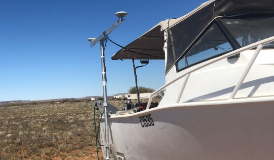
• Multi rotor Real Time Kinematic (RTK) positioning UAV

• RTK Base-station and ground control points

• Geographical Information Systems (QGIS)

• Statistical Analysis R, Primer, SPSS

• Agisoft Metashape Pro Software

• Final Cut ProX editing Software

Geo Spatial Surveys

• Coastal Erosion Monitoring through accurate Digital Elevation Modeling (DEM)

• Detailed site planning

• Asset inspection

• Disturbance and rehabilitation Surveys

Get in touch with us: